White Pocket: The Place the Desert Keeps to Itself
If it is your first drive to White Pocket and you are not very experienced with true four-wheel driving, offline maps, and GPS navigation, you should ask yourself, "What am I doing here?” The pavement ended hours ago when you turned off US 89 or US 89A onto House Rock Valley Road. In most places coming from the south, off US 89A, House Rock Valley Road is a good gravel road, but with lots of washboards. In the Buckskin Gulch area off US 89, it can be rutted and rough and, after rain, impassable.
So why would you want to come here?
The answer lies at the end of that drive. White Pocket is one of the most genuinely otherworldly landscapes on Earth. I don't say that lightly, and I've seen a few. White Pocket stopped me cold when I first walked up from the parking area, even though I had heard about it 11 years earlier and had seen countless photos of it.
The stark beauty of White Pocket sits atop the Vermilion Cliffs National Monument on the Arizona-Utah border, roughly 38 miles from Kanab and 36 miles from Page. There are no facilities. There is no permit system, no fee, and no reservation — you can simply go if you can get there. Please check the BLM website for road conditions and the specific recommended route, and download the route to your GPS device so you can follow it. There are other roads on the maps, but they are even rougher. Sometimes the road signs are missing. You don’t want to be stuck on one of those other roads. There is ZERO cell service.
Days End, White Pocket, Vermillion Cliffs National Monument, AZ
The Geology That Makes White Pocket Look Like an Alien World
White Pocket is Navajo Sandstone — the same 190-million-year-old formation that underlies much of the Colorado Plateau, the same rock that produces Zion’s iconic orange-red slickrock, and the same geological layer responsible for the Wave formation at Coyote Buttes North, roughly six miles to the northwest.
Same rock. Wildly different outcome.
The Navajo Sandstone began as an enormous Jurassic desert, a sand sea that covered much of what is now the American Southwest — geologists compare it to the Sahara in scale. Over millions of years, those dunes were buried beneath successive layers of sediment, compressed, and cemented into rock. The iron oxides in the sand gave most of the resulting sandstone its characteristic warm orange-red color.
At White Pocket, something different happened. The white color — chalky, almost luminous, genuinely striking against the surrounding red rock landscape — comes from silica-rich sandstone bleached over millions of years, with iron oxides stripped away by groundwater moving through the formation. But the color is almost secondary to the structure. What makes White Pocket genuinely strange and beautiful is the deformation.
The dominant visual feature is what geologists call deformation structures — areas where the sandstone was disturbed before it fully lithified, while it was still saturated with water and subject to movement. The result is rock that was folded, stirred, and kneaded while it was still essentially wet. The texture looks biological rather than geological: brain-like convolutions, twisted ribbons of white and red, bubbled surfaces that resemble coral or cauliflower more than any stone you've seen. Polygonal plates of white rock, fractured and tilted at odd angles. Iron-oxide streaks bleeding through white like watercolor on wet paper.
Most geologists attribute White Pocket to soft-sediment deformation followed by groundwater-driven alteration, though the details of these processes remain debated. They agree on the outcome: White Pocket is geologically unique. There is nowhere else on Earth that looks quite like this.
Scattered across the lower areas of the formation are the Moqui marbles — spherical iron concretions ranging from marble-sized to baseball-sized, formed when iron minerals precipitated from groundwater around a grain of sand. They litter rock surfaces and pool in low spots, and they've attracted scientific attention beyond their visual appeal: NASA studies Moqui marbles because Mars has produced almost identical formations, called "Martian blueberries," suggesting the red planet once had flowing groundwater.
Clearing Monsoon, White Pockets, Vermillion Cliffs National Monument, AZ
First Impressions
I arrived from the south on US 89A, reminiscing about my first western road trip nearly 50 years ago. That was my first time seeing the Vermillion Cliffs on my way to the Grand Canyon, and I wondered what the hell was on top of them. I figured it out about 11 years ago, but I had never seen it in person. I was excited to see and photograph White Pocket. It was mid-morning when I turned onto House Rock Valley Road. I aired down a bit because my pop-up truck camper rides like a semitrailer. After turning onto the BLM’s recommended route to White Pocket via BLM 1065, 1017, 1087, and 1086, I aired down further to avoid getting stuck in sand. I had no issues and was fully prepared, but some anxiety from the hardest, most remote dirt road I had ever driven did interfere with my excitement of finally getting to White Pocket.
What a WOW factor, even with a shadowless midday sun. I explored and found the spots I wanted to shoot during golden hour. I got even luckier with the arrival of an early monsoon lightning storm. It filled the pockets with water as I waited it out, creating perfect light, rainbows, and clouds. I was overwhelmed, almost to the point of paralysis, and unsure what to shoot. Even with all the other pictures I saw online, White Pocket’s beauty still surprised me.
Twisted Brain Rock, White Pockets, Vermillion Cliffs, National Monument, AZ
A Monument Is Born
Vermilion Cliffs National Monument was established by presidential proclamation in November 2000, protecting 294,000 acres of the Colorado Plateau in northern Arizona. It encompasses an extraordinary collection of geological features — the Paria Canyon-Vermilion Cliffs Wilderness, the Coyote Buttes formations, Buckskin Gulch (one of the world’s longest and deepest slot canyon systems), and the Paria Plateau, on which White Pocket sits.
The monument is managed by the Bureau of Land Management, not the National Park Service — a distinction that matters for its management. BLM lands generally operate under a multiple-use mandate that balances recreation, grazing, and other uses, with less infrastructure and fewer regulations than NPS units. Vermilion Cliffs has no entrance station, no paved roads into the backcountry, and minimal staffing relative to its scale and visitation.
The monument's most famous feature is Coyote Buttes North — officially "The Wave," a sinuous formation of layered Navajo Sandstone in flowing bands of orange, pink, and red, which has become one of the most photographed landscapes in America. The Wave has been subject to a strict permit lottery system since 1996, and the current system limits daily visitation to 64 people — 48 through an advance lottery on Recreation.gov (open four months before the visit date) and 16 through a daily lottery two days prior. During peak season, an estimated 300 people apply for those 16 daily permits. The advance lottery is similarly oversubscribed. Securing a Wave permit requires either extraordinary luck, strategic multi-month application campaigns, or both.
Coyote Buttes South — a less-famous yet equally remarkable area of contorted sandstone south of The Wave — also requires a permit, with 20 people allowed per day under a similar lottery system.
Until now, White Pocket has required neither permit nor fee. It is free, open, and self-governing — limited in practice only by the formidable barrier of the approach roads.
Golden Hour, White Pockets, Vermillion National Monument, AZ
What the BLM Is Considering to Protect It
When I visited White Pocket, I saw a sign at the trailhead stating that the BLM was considering changes to how the site is managed. That notice marked the start of a formal process that became public in May 2024.
The BLM published a draft business plan for the Paria Canyon/Coyote Buttes Special Management Area and White Pocket, seeking public comment through June 2024. The document is candid about the pressures driving the review.
Visitation at White Pocket has risen substantially — the same post-pandemic surge that has strained Dolly Sods and dozens of other public lands has reached even here, despite the 4WD requirement and the remote location. The BLM's own language in the proposal states the situation plainly: "The amount of human waste has become more problematic." A pump truck cannot reach the site through the deep sand, so there are no toilets and no way to service them if there were any. The first proposed use of fee revenue is to install a composting toilet.
Beyond the sanitation issue, the BLM identified the need for improved signage, designated parking areas, visitor safety infrastructure, and ongoing field patrols. The current fee and volunteer patrol operations across the Paria Canyon corridor cost roughly $100,000 per year, covered by existing recreation fees from The Wave and other permitted areas. White Pocket currently contributes nothing to that operational cost while drawing significantly on the same staff and patrol resources.
The proposed fee structure would establish a $10 per-person day-use fee at White Pocket. The proposal also discusses the possibility of a permit system — though as of the close of the public comment period in summer 2024, the primary immediate proposal was the fee rather than a hard cap on daily visitors.
Sunrise, White Pocket, ermillion Cliffs National Monument, AZ
As of this writing in June 2026, the fee and permit system have not yet been formally implemented. White Pocket remains free and open. However, the process is underway, and the direction is clear.
I believe a $10 fee per person is a small price to pay, especially when compared with the cost of getting there on your own or the cost of a guided tour. With massive cuts to funding for public lands, this $10 is necessary to help protect them.
I don’t want to see the road improved. It is fine as a four-wheel-drive road as long as it does not deteriorate significantly. I easily got an 8000-lb pop-up truck camper up there, and I seldom take four-wheel-drive roads. It keeps the unprepared from going there while still allowing small-group tours to bring a limited number of visitors. The two days I was there, there was one other family camping who left the day I arrived, two individual 4X4 small groups, and three 4X4 tours. Fewer than twenty people both days. Maybe in the future, put some limits on tours.
I would like to see better education on how to visit safely and leave no trace, using both signage and, for tour groups, providing safety and minimal-impact training at the start of a trip. Several people on tours I saw had old-fashioned hard-soled boots. I would like to see the BLM encourage soft-soled shoes.
There is a set of practices that you can follow that will mitigate damage and, therefore, delay the need for more restrictions. These practices are common sense: Leave No Trace. Take only pictures, leave nothing. More specifically:
Take out everything you bring in, including human waste and any “graywater” you may use. Camp in a self-contained vehicle with tanks to prevent spills of human waste or graywater. If you use a tent, bring the necessary containers to pack ALL waste out, including pee and poop. These restrictions are similar to those on the White Rim Road in Canyonlands National Park. Also, they are really easy to do.
Even though there are no formal trails, soft-soled shoes will work and grip the steeper rocks better and delay damage to the rock.
If you'd rather not navigate the approach yourself, authorized guided tours depart from Page and Kanab and provide knowledgeable drivers who know where the deep sand is and where the named formations are.
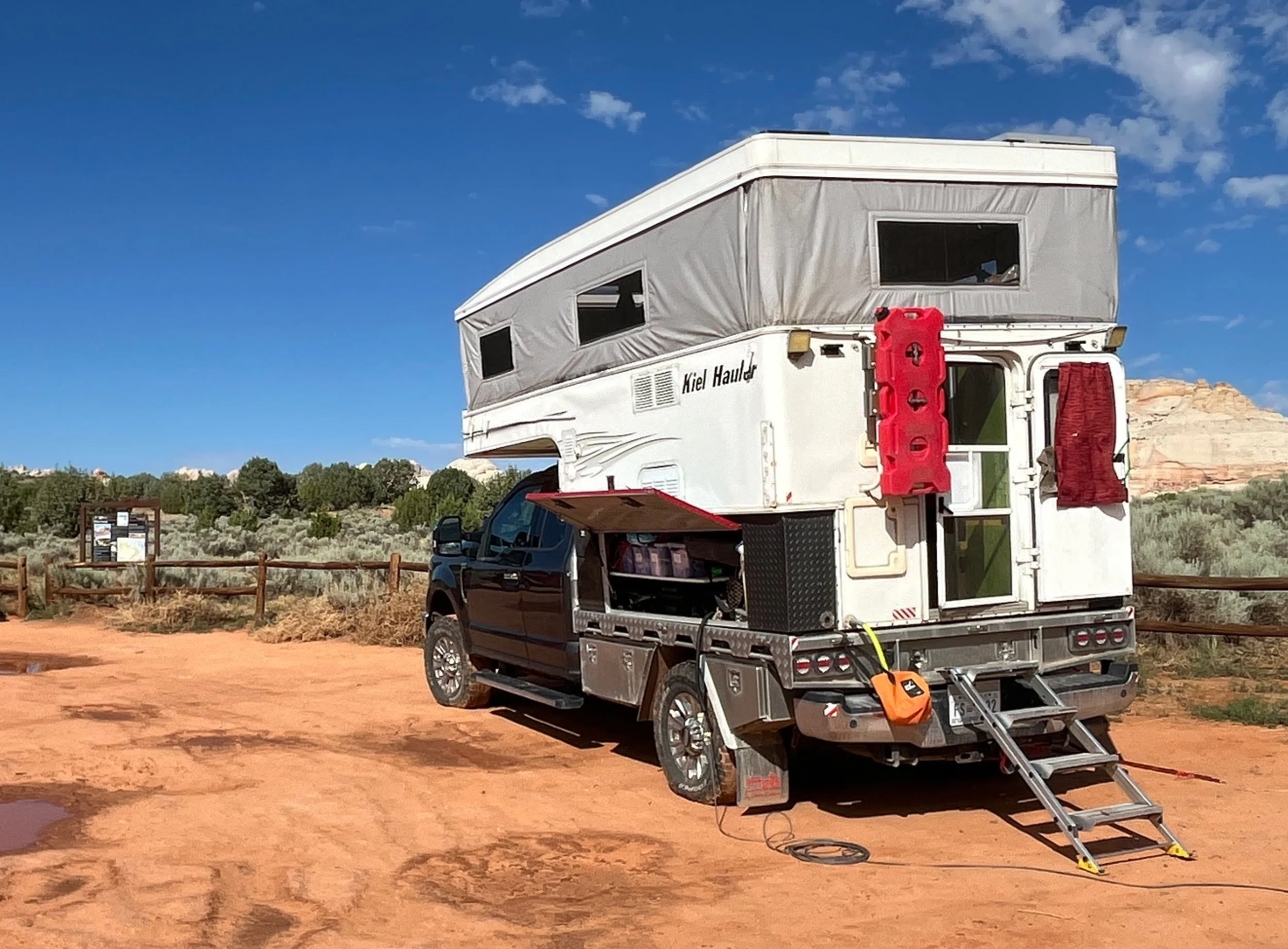
Our Trusty Truck Camper
Why It Matters — and What I Was Trying to Photograph
I went to White Pocket to see it, enjoy it, and try to capture my interpretation of its rugged, remote splendor. I really wish I had been among the first photographers to visit before it was “discovered.” I know many of my shots have already been photographed hundreds of times. Still, with the unique combination of golden hour, receding storms, and the subtle colors of dusk, I think I managed to capture something new. I hope you enjoy my work and that it inspires you to recognize the beauty of America’s wild places and their need for preservation.
The photographs are an attempt to document something genuinely irreplaceable. Not in the sentimental sense — in the geological sense. You cannot make a new White Pocket. If it is destroyed, it is gone forever. What the BLM is trying to determine now is how many people can visit it before we begin to diminish it.
The photographs from White Pocket and Vermilion Cliffs National Monument in the Southwest portfolio are available free of charge with limited use rights for conservation organizations and government land agencies working in the Colorado Plateau region. If you represent an organization interested in these images, please visit the “Work with Me” page on OurLandPhotography.org.