Dolly Sods: Can You Love a Wilderness so Much it Hurts?
I've been coming to Dolly Sods for a long time. Long enough to remember when you could park at Bear Rocks on a Saturday morning in October and count the other cars on one hand. Long enough to watch this place go from a well-kept secret to an Instagram destination, and to feel the complicated mix of pride and unease that comes with it.
Every place has a layered history. Dolly Sods has several. An industrial assault stripped the plateau to bare rock. An army used what was left for target practice. A decades-long conservation battle secured its permanent protection. Finally, a slow, stubborn resurrection — one that's still underway and now being tested by a new kind of pressure.
This is that story.
What It Looked Like Before
To understand Dolly Sods, you first have to let go of the landscape you see today.
The original Dolly Sods was a dense, ancient forest of red spruce, eastern hemlock, and black cherry — trees that reached 60 to 90 feet tall, some more than four feet in diameter. When the 1746 Fairfax survey party passed through, surveyor Thomas Lewis recorded that the woods were so dense that "horse or man could hardly force his way through it." That survey, led by Peter Jefferson and accompanied by a young George Washington two years later, placed the Fairfax Stone just north of what is now the wilderness — one of the earliest European records of this landscape and a testament to how impenetrable it still was.
Within that old-growth forest, naturally occurring openings existed. The Dahle family — German immigrants who settled the area in the late 1700s, with their name anglicized to "Dolly" by local pronunciation — grazed sheep and cattle on the natural mountaintop meadows at the southern end of what is now Rohrbaugh Plains. The Shawnee, Seneca, and other indigenous nations who used the Allegheny highlands likely managed those same open areas through periodic, low-intensity burning to improve wild blueberry production — a documented practice across the eastern woodlands. The WV Department of Natural Resources notes that "burning for blueberry production may have also been a driving force" in shaping the Dolly Sods heath barrens long before European settlement.
These open sods, along with the scattered bogs and heath barrens along the Allegheny Front, were islands in a sea of old-growth forest. The vast open landscape we see today — the sweeping blueberry fields, the flagged spruce silhouettes, the boulder-strewn plains — is almost entirely the result of what happened next.
Potomac River Valley from the Eastern Continental Divide, Bear Rocks, WV
A Managed Landscape: The First Stewards
Before the loggers, before the Dahle family, before the Fairfax surveyors, the Allegheny highlands were indigenous land. The Shawnee, Seneca, Lenape, and other nations moved through and used what is now eastern West Virginia. The Seneca Trail — part of the broader Great Indian Warpath network stretching from New York to Alabama — ran through this region. These were not wilderness crossings; they were well-established routes through a landscape these peoples knew intimately across generations of accumulated ecological knowledge.
The Dolly Sods plateau, exposed and cold, would not have been a habitation site. But it was almost certainly managed — as hunting ground, as a travel corridor along the Allegheny Front, and as something more deliberate: a tended food resource.
The plateau's scattered sods and rocky heath barrens were prime wild blueberry habitat. Wild blueberries thrive in exactly the conditions Dolly Sods provides — thin, highly acidic soils, high elevation, rocky and well-drained terrain. Indigenous peoples across the eastern woodlands had long understood that periodic, low-intensity burning of blueberry patches dramatically increased berry production. The fire kills competing vegetation and clears pests, but the blueberry plant itself — with roughly seventy percent of its mass underground in an extensive root system — survives and responds with vigorous new growth. The following season's harvest is larger, denser, and more productive.
The West Virginia Department of Natural Resources states this explicitly: "burning for blueberry production may have also been a driving force" in shaping the heath barrens of Dolly Sods "before and after white settlement." The Highland Outdoors publication describing Bear Rocks notes that "the Allegheny Front has a storied history dating back hundreds of years to when Native Americans practiced prescribed burning to encourage the growth of food-producing shrubs." What we know from parallel traditions among the Wabanaki of Maine, the Ojibwe of the Great Lakes, and tribes throughout the southern Appalachians is that this wasn't random fire-setting — it was cultivation. Careful, seasonal, intentional management of a food resource using a tool refined over thousands of years.
The Stewards who hike these trails today are aware of this history. The plateau's sods were a managed landscape long before the loggers arrived — tended by periodic, low-intensity fire in the service of a food resource that mattered. It wasn't the forest primeval. It was a garden.
That distinction matters when we get to what happened next. Because the industrial fires that followed used the same basic ecological mechanism — fire opening the canopy and expanding the barrens — but performed it at catastrophic, uncontrolled scale. The indigenous burns were surgical. What the logging era unleashed was an inferno.
Ferns and Pines along Fisher Springs Run Trail
The Rape of the Plateau
What happened to Dolly Sods between roughly 1880 and 1930 is one of the great ecological catastrophes of eastern American history — and one that many visitors today have no idea occurred.
The timber industry arrived in earnest in the 1880s. Parson Pulp and Lumber established band sawmills at Laneville, and a network of logging railroads climbed the mountain. The trees that Lewis had found too dense to ride a horse through were gone within a generation. By the early 1900s, the plateau was stripped bare.
What the loggers left behind became a tinderbox. Sparks from locomotives, lightning, and cook fires ignited the dried slash and peat. Fires burned for weeks, then months, smoldering through the organic layer until they reached bare rock. An estimated six feet of topsoil was lost in some areas. In July 1930, a single conflagration swept across 24,800 acres. More than one-tenth of West Virginia's land area burned during this era. As documented by the West Virginia Center on Budget and Policy, the pattern of resource extraction—whether timber, coal, or gas—has historically led to temporary economic prosperity followed by long-term economic instability, leaving local populations in perpetual cycles of poverty once the resource is depleted.
The railroad grades those locomotives traveled on are still visible today. The Dobbins Grade Trail — one of the most-used routes in the wilderness — runs directly over the bed of one of those logging railroads. It is fittingly one of the wettest trails in the area, built on a gravel railbed that retains moisture and channels runoff. The volunteer Wilderness Stewards make a point of telling hikers something counterintuitive: stay on the trail, even when it's muddy. The compacted gravel actually supports your weight better than the surrounding saturated soil. Going around the mud is precisely how the trail corridor widens into the sensitive heath barrens flanking it, leaving you covered in more mud after disrupting the micro-ecosystems that live there.
Then the Army came. Beginning in 1943, the U.S. military used Dolly Sods as an artillery and mortar training range. Shell craters are still visible, softened by moss and ferns. Warning signs at trailheads remind visitors not to disturb metallic objects — unexploded ordnance is still occasionally found.
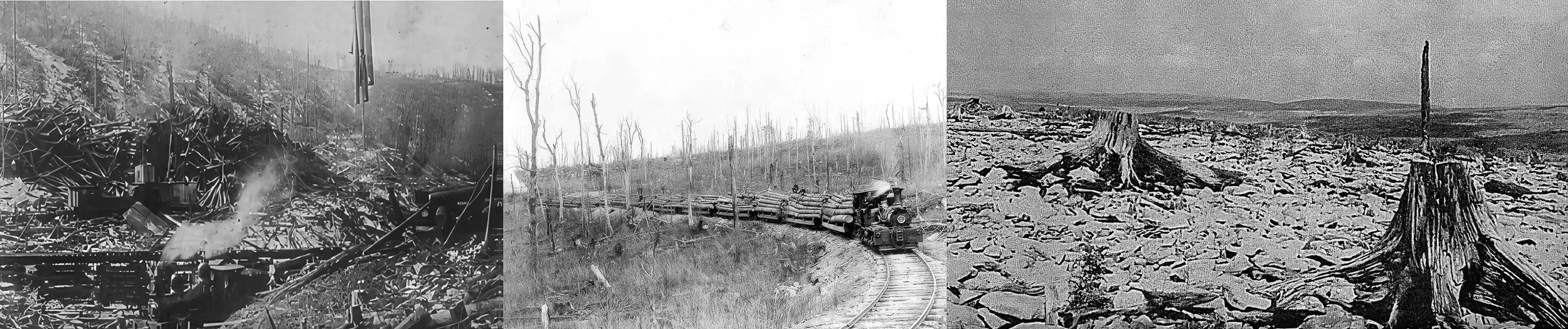
Left: Steam skidder dragging felled trees and loading onto the train on the right fork of Red Creek. Middle: Hauling out the trees along Dobbins Grade. Right: Burned wasteland on Cabin Mountain, which is still recovering.
The Long Return — and the Battles That Made It Possible
What emerged from all of that is remarkable. The harsh conditions that made the logging era so destructive — thin soils, high winds, acid-forming bedrock — also made rapid forest recovery impossible, which in turn created something that doesn't exist anywhere else at this latitude. The heath barrens of blueberry, huckleberry, rhododendron, and azalea. The sphagnum bogs. The wind-stunted red spruce, shaped by prevailing westerlies into the flagged silhouettes that define the skyline. The plant communities of Dolly Sods are ecologically similar to the Shield region of Canada rather than to the central Appalachians — a boreal ecosystem created by catastrophe and sustained by the same harsh conditions that caused it, even though the regions are very different geologically.
But recovery as a wild land was not guaranteed. By the late 1960s, the recovering plateau faced new threats — most seriously, coal mining. The coal seams beneath Dolly Sods were real and valuable, and with mineral rights still in private hands, strip mining was a real possibility that would have been the “boom-bust cycle” of extractive industries.
Two of the best-known organizations secured the place's future, each in a distinct way. The West Virginia Highlands Conservancy, founded in 1967, drove the advocacy campaign — publishing the first wilderness proposal and trail guide in 1969, challenging the Forest Service's "purity doctrine" that excluded disturbed lands from wilderness consideration, and ultimately winning the 1975 Eastern Wilderness designation. Helen McGinnis, a Conservancy leader whose decades of work on this campaign was recently honored in a documentary, was central to that victory. The Conservancy was also instrumental in the 2009 expansion to the current 17,776 acres and formed the Dolly Sods Wilderness Stewards in 2021.
The Nature Conservancy played a different but equally critical role: in 1972, TNC purchased approximately 15,000 acres of coal rights beneath the future wilderness and transferred them to the Forest Service. Without that transaction, the 1975 designation would have protected the surface while leaving the subsurface vulnerable to strip mining. TNC has remained active in the landscape ever since, acquiring Bear Rocks Preserve at the northern wilderness edge and Mount Porte Crayon Preserve on the Roaring Plains. The newly acquired 1,393-acre Dobbins Slashing Preserve permanently protects the largest intact peatland adjacent to the Dolly Sods Wilderness, securing a critical subalpine ecosystem and the vital headwaters of Red Creek. This massive tract serves as a strategic climate buffer, mitigating biodiversity loss and connecting the Dolly Sods Wilderness Area directly to the Canaan Valley Wildlife Refuge. For outdoor recreationists, this critical physical link enables the creation of an expansive, continuous 80-mile trail network spanning multiple management organizations.
Dolly Sods doesn't stand alone. Immediately to the south lies the Roaring Plains West Wilderness (6,792 acres). To the northwest, the Canaan Valley National Wildlife Refuge protects the largest inland wetland complex in the eastern United States. TNC's Bear Rocks and Mount Porte Crayon Preserves buffer the wilderness edges. All of it sits within the Monongahela National Forest — 919,000 acres containing eight designated wilderness areas. Together, these lands form one of the most ecologically significant protected landscapes in the eastern United States. This essay focuses on Dolly Sods because that's where visitation pressure is most acute. If the crowds become unmanageable, the Roaring Plains to the south offer similar terrain and a fraction of the foot traffic. On your next visit, to mitigate pressure on Dolly Sods, consider visiting the nearby Roaring Plains West Wilderness and the Flat Rocks Plain areas of the Monongahela National Forest. The trails are harder but offer similar experiences and far more solitude.
One of many unnamed falls along Red Creek.
The New Pressure
Visitation surged after 2020 and hasn't returned to normal levels. Between 2022 and 2023 alone, it increased by an estimated 15 percent. Hikers detour around muddy sections, and those detours become new trails. A campsite survey identified roughly 350 sites throughout the wilderness, many with bare soil, illegally felled trees stripped for firewood, rocks uprooted for furniture, and huge fire pits.
My wife and I recently had the opportunity to join two Dolly Sods Volunteer Trail Stewards for a guided, highly informative hike along Dobbins Grade Trail. As we hiked along the meandering Right Fork of Red Creek, they described the history, geology, ecology, and pressures on Dolly Sods. They pointed out evidence of damage caused by “City Slicker Campers,” who are not well-versed in conservative camping practices. We saw the evidence the campsite survey documented, including huge rock fire circles, large rock furniture, the cutting of live trees that barely burn when freshly cut, the burning of trash with the leftover remains in fire pits, and fences built around a campsite. Given the number of backpackers out there today, this represents an unacceptable impact on the wilderness experience and a disruption to the lives of critically important species like the Cheat Salamander.
Proportion matters here. The logging era destroyed six feet of topsoil and burned the plateau to bare rock. The WWII artillery range left unexploded ordnance in the ground. Nothing happening today approaches that scale of destruction. The wilderness is not dying — it is still recovering, still resilient, still remarkable, but the wilderness experience is being diminished.
What current visitation does is slower and more subtle: it may delay recovery in specific areas, widen trail corridors into fragile heath barrens, disrupt some of the area’s unique and critical species, and erode the wilderness experience — the solitude, the sense of being somewhere truly apart — that the 1975 designation was meant to protect. A century ago, the plateau was a moonscape. The threat today is to the pace of recovery and the character of the place, not to its survival.
Self-portrait at Lions Head. Note the typical Dolly Sods mud on my legs during a hike.
The People Holding the Line — and What They Can't Do
The Dolly Sods Wilderness Stewards, formed in 2021 by the West Virginia Highlands Conservancy and the Monongahela National Forest, now includes more than 100 volunteers. Trailhead Stewards station themselves at the busiest entry points on peak weekends — handing out trail maps, explaining Leave No Trace principles, and answering questions. The conversations are brief, 30 to 60 seconds, but most people who come here genuinely care about the place. They just need to know how specific choices affect it. Beyond the trailheads, the Stewards conduct trail maintenance, campsite surveys, and backcountry patrols.
We learned during the guided hike with the Stewards that education is essentially all the Stewards can do. There are no entry fees at Dolly Sods, and there are no campfire restrictions beyond wilderness baseline rules — which call for small campfires. The Forest Service, acutely aware of local sensitivities around land-use rights in the communities that have lived alongside these highlands for generations, moves carefully with any management tool that might feel like a restriction. The local love for Dolly Sods — from as far away as Ohio, or the communities of Tucker and Grant counties, who have hunted, fished, and gathered here for generations — is deep and genuine, and that relationship with the land is not the problem. Navigating that tension honestly, without dismissing either side, is the central challenge facing Dolly Sods right now.
The primary tool available is a volunteer with a trail map and a 60-second conversation. Those volunteers are doing remarkable work and deserve more institutional support than they're receiving. Listen to their advice and consider volunteering.
Moonrise over the Eastern Continental Divide.
What Might Actually Help
There are no easy solutions, but approaches that have worked successfully elsewhere include: timed entry or reservation systems at the most-impacted trailheads to spread visitation without limiting overall access; designated camping zones with enforced site limits to slow campsite proliferation; a modest user fee to fund restoration and the ranger presence that volunteer programs can't replace; and increased Forest Service staffing in the Monongahela. The Stewards are filling gaps that shouldn't exist.
None of these are politically easy, nor will they be readily endorsed by all. All require money, political will, or both. The wilderness will absorb this overuse. It has absorbed the loggers, the fires, and the artillery. The question isn't whether Dolly Sods survives — it's what it looks like when we're done with it and whether the wilderness experience that drew people here remains intact for those who come after us.
Big Stonecoal Falls
Getting There Responsibly
Go on weekdays when you can. A Tuesday in September is a fundamentally different experience from a Saturday.
Stay on trail — even when it's muddy. Especially on the Dobbins Grade, Big Stonecoal, and Rohrbaugh trails. The gravel railbed of Dobbins Grade supports your weight better than the surrounding saturated soil. The mud washes off your boots; the new trail corridor doesn't recover on any timeline you'll live to see.
Camp in existing sites. Don't create new ones. Don’t leave anything you brought in. Don’t build huge fire pits and rock furniture.
Consider the surrounding national forest, state parks, and the nearby Wildlife Refuge, and Roaring and Flatrock Plains, a few minutes south. Similar terrain, similar views, a fraction of the foot traffic.
Support the Wilderness Stewards at wvhighlands.org.
The photographs in the Appalachia & the East portfolio from Dolly Sods Wilderness are available free of charge for use by the West Virginia Highlands Conservancy The Nature Conservancy, the Monongahela National Forest, and conservation organizations working in this landscape. If you represent an organization interested in these images, please visit the Work with Me page.